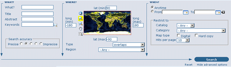
The advanced search option (Figure 2.6, “Advanced search options”) works similarly to the default search. However, you can be more specific in your search criteria as it offers different elements to look for data, each of them focussing one of the following aspects: What?, Where?, When?
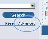
To perform an advanced search , from the home page click Advanced just below the search bottom (see Figure 2.7, “Show advanced search options”).
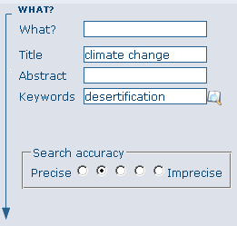
In the WHAT? section the elements are all related to the data content. Through them, in addition to searching only free keywords in the entire metadata content, you can also search directly in the title or abstract fields and add more keywords to customize your search further. You can also specify the level of accuracy you wish to reach in performing your search (Figure 2.8, “"What" section in the Advanced search”).
To search by Title, Abstract, Free Text, or Keyword(s) type any text into the respective field. You can enter information in one or multiple field(s). If you do not want to search by a given field, simply leave it blank;
You can choose the accuracy of your search, in terms of spelling words, from Precise = 1 to Imprecise = 0.2, through 3 more consecutive steps which are equal to 0.8, 0.6, 0.4.
The WHERE? parameters, which are related to the spatial extent, allow you, as in the default search, either to select your own area of interest or to select a predefined region from the drop-down list. In this section you can also type the geographic coordinates of a specific location that is not available from the above list. (Figure 2.9, “"Where" section in the Advanced search”)
To select your own area of interest, drag and drop the frame of your area on the global map using the appropriate tool on the bottom left of the map screen;
To use free coordinates, type the lat-long geographic references in the appropriate fields around the map screen, without any limitation of decimal figures;
To use the coordinates of a predefined region, select the region from the drop-down list.
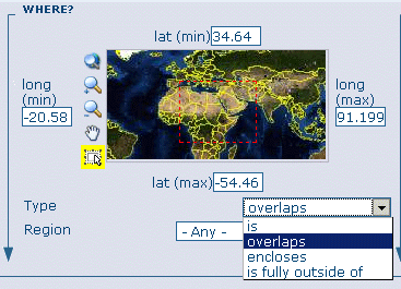
Whatever type of geographic search you decide to perform, in the Spatial search type field, you can choose from different options: is, overlaps, encloses, is fully outside of (Figure 2.9, “"Where" section in the Advanced search”). If you use this field, be cautious as this limits your output data as follows:
If you choose Spatial search type is “Country”, only maps for the selected country will be displayed. In other words, a city map within that country will not show in the output results.
If you choose Spatial search type overlaps “Country”, all maps with the bounding box overlapping that country will be displayed in the results, i.e. the neighbouring countries, the continent of which that country is part of and the global maps.
If you choose Spatial search type encloses “Country” you will get, in the output results, maps of that country first and then all maps within its bounding box.
Similarly, if you choose Spatial search type is fully outside of a selected region, only maps that follow that exact criteria will show in the output results.
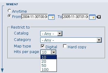
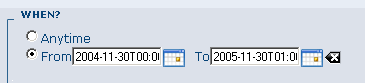
The WHEN? section gives you the possibility to restrict your search in terms of temporal extent, indicating a specific range of time referred to the data creation or publication date (Figure 2.10, “"When" section in the Advanced search”).
To specify a range of time, click on the date selector button next to From – To fields. Make use of the symbols > and >> on top of the calendar to select the month and the year first and then click on the exact day; a complete date will be filled in using the following standard order: YY-MM-DD.
To clean the time fields, simply click on the white cross on their right; the box Any will be automatically selected and the search will be performed without any restriction on the time period.
Finally, the advanced search allows you to apply further restrictions on the basis of additional parameters as data source, data categories and data format (Figure 2.11, “Other options in the Advanced search”).
To limit your queries to only one Catalog out of those made available by the installation through the harvesting process, highlight the catalog of preference or just keep Any selected to search all sites. (See more info about data harvesting in Section 4 Chapter 1 of these guidelines).
To search for data organized by Category, such as Applications, Datasets, etc., simply highlight the category you wish to search in from the related drop-down list, otherwise we suggest to leave this field in Any Category.
You can search for Digital or Hard Copy maps. To search in one or the other, simply check the box next to the one you wish to search. If no box is checked, all content will be searched.
At last, you can customize the number of output results per page in the Hits Per Page field. Simply highlight the number of records to be displayed or leave the field set on the default number (10).
Click the Search button.